Projects
Publications
This page is an attempt to list the projects using the GAMA platform as a modeling and simulation platform. Interesting readers can also have a look at the page listing the Ph.D. theses and articles related to and/or using GAMA platform.
Projects
SWITCH: Simulating the transition of transport Infrastructures Toward smart and sustainable Cities (ANR 2019- )
Description:
Transport infrastructures play a large part in defining the city of the future, which should be smart, sustainable and resilient. Their management will need to deal with the emergence of novel technologies (i.e. autonomous cars, Internet of Things) and the increase of novel modalities and practices (increase of multi-modality, electric bicycles, shared cars). The SwITCh project aims at supporting decision-making for urban planning by simulating the gradual introduction of disruptive innovations on technology, usage and behaviour of infrastructure. It requires providing a model that is able to assess the impact of these innovations on several key indicators on mobility, user satisfaction and security, economic costs and air pollution. SwITCh integrates a large variety of urban transport modalities (private car, walk, tramway, etc.) and associated infrastructures (pavement, bicycle path, etc.). It uses agent- based modelling (ABM) and participatory simulation as a unifying framework that allows coupling different models and taking into account both temporal and spatial scales in order to build a holistic model. The resulting interactive simulator and serious game will be used by the city planners to explore the potential impact of innovations in various contexts, test and assess different alternatives and situations in two case studies: Bordeaux Metropole and the Urban Community of Dijon.
Website: https://www6.inrae.fr/switch
Contact: Franck Taillandier
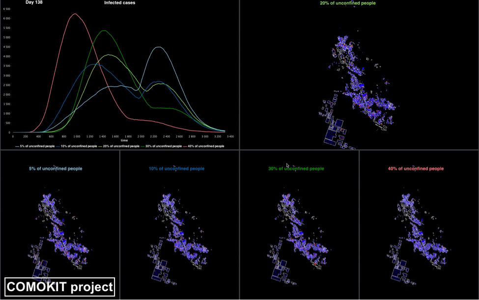
COMOKIT (2020- )
Description:
Since its emergence in China, the COVID-19 pandemic has spread rapidly around the world. Faced with this unknown disease, public health authorities were forced to experiment, in a short period of time, with various combinations of interventions at different scales. However, as the pandemic progresses, there is an urgent need for tools and methodologies to quickly analyze the effectiveness of responses against COVID-19 in different communities and contexts. In this perspective, computer modelling appears to be an invaluable lever as it allows for the in silico exploration of a range of intervention strategies prior to the potential field implementation phase. More specifically, we argue that, in order to take into account important dimensions of policy actions, such as the heterogeneity of the individual response or the spatial aspect of containment strategies, the branch of computer modeling known as agent-based modelling is of immense interest. We present in this paper an agent-based modelling framework called COVID-19 Modelling Kit (COMOKIT), designed to be generic, scalable, and thus portable in a variety of social and geographical contexts. COMOKIT combines models of person-to-person and environmental transmission, a model of individual epidemiological status evolution, an agenda-based one-hour time step model of human mobility, and an intervention model. It is designed to be modular and flexible enough to allow modellers and users to represent different strategies and study their impacts in multiple social, epidemiological or economic scenarios.
COMOKIT aims at supporting deciders in answering the most pressing of these questions using an integrated model that combines:
- A sub-model of individual clinical dynamics and epidemiological status
- A sub-model of direct transmission of the infection from agent to agent
- A sub-model of environmental transmission through the built environment
- A sub-model of policy and interventions design and implementation
- An agenda-based model of people activities at a one-hour time step
Website: https://comokit.org/
Contact: Alexis Drogoul
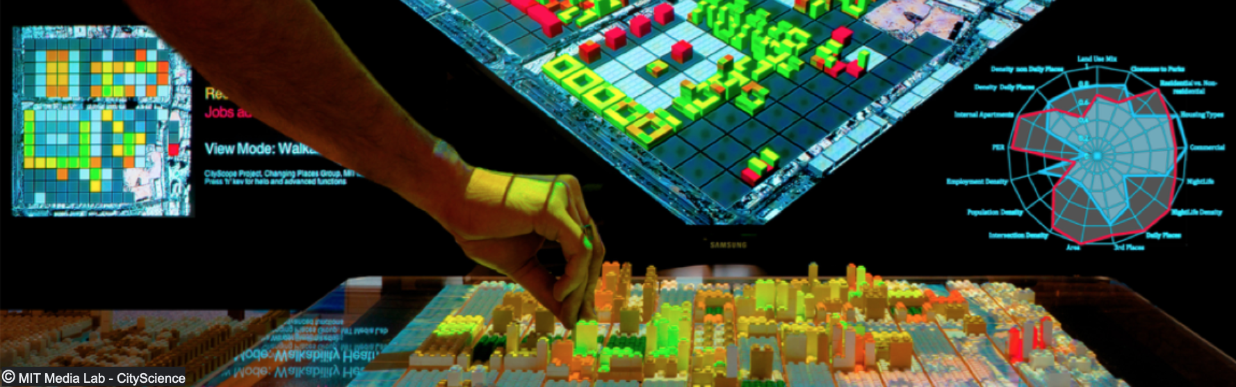
CITYSCOPE (2016- )
Description:
City Science researchers at the MIT Media Lab are developing CityScope, a tangible and digital platform dedicated to solving spatial design and urban planning challenges. The tools developed range from simulations that quantify the impact of disruptive interventions in cities to communicable collaboration applications. The team develop and deploy these tools around the world in a so-called CityScience Network and maintain open source repositories for the majority of deployments. "CityScope" is a concept for shared, interactive computation for urban planning.
In this context GAMA has been used in different applications and projects since 2016, as one of the main agent-based simulation platform for research project aiming at understanding behavioural patterns towards housing and mobility mode in urban policy design. Since 2021, this project is being co-developed between France, Vietnam and USA as part of the EU-funded Marie Curie FellowShip Project, ReAgent
Website: https://www.media.mit.edu/projects/cityscope/overview/
Contact: Arnaud Grignard
TSH-system project (2021-)
Description: The main objective of the project is to develop decision-making tools to support urban Transport-Spaces-Humans system planning and design.
The project aims to assist in:
- analysing the interdependence between the urban transportation system, public space system, and their users both qualitatively and quantitatively at multiple spatial dimensions;
- quantifying the impact of architecture layouts and transport-land use plans;
- predicting the usage of different land uses, activity supports, automobile travel demands, active travel demands, and transport mode choice;
- supporting the selection of plan scenarios.
Publication:
Website: https://nmyangliu.wixsite.com/tsh-system
Contact: Liu Yang (Research Fellow in the School of Architecture, Southeast University (Nanjing, China))
LittoSIM / LittoGEN / LittoKong (2015-)
Description:
LittoSIM is a participatory simulation platform for local actors. The serious game is presented in the form of a simulation integrating both a model of marine submersion, the modeling of actors acting on the territory (defense association, State services, etc.), and game actions performed in situ by elected officials and technicians (municipalities and inter-municipal authorities). The simulation focuses on the southwestern tip of the island of Oléron and offers a reflection on the effects of types of land use planning on the management of the risk of submersion (frontal defenses, modes of urbanization, soft defenses, withdrawal strategic). The game aims to explore different scenarios for managing the risks of submersion, the course of which is induced both by the players' layout choices and by the simulation as such, thus constraining the trajectories of the game.
This companion modeling is an opportunity to provide testimony on the learning effects that the game allows for elected officials and managers, and therefore on the apprehension of space and territory in situ by the actors of the development.
The LittoSIM project has been extended on several other case studies in France (through the LittoGEN project) and in Vietnam (through the LittoKONG project).
Publication:
Website: https://littosim.hypotheses.org/
Contact: Nicolas Bécu and Marion Amalric
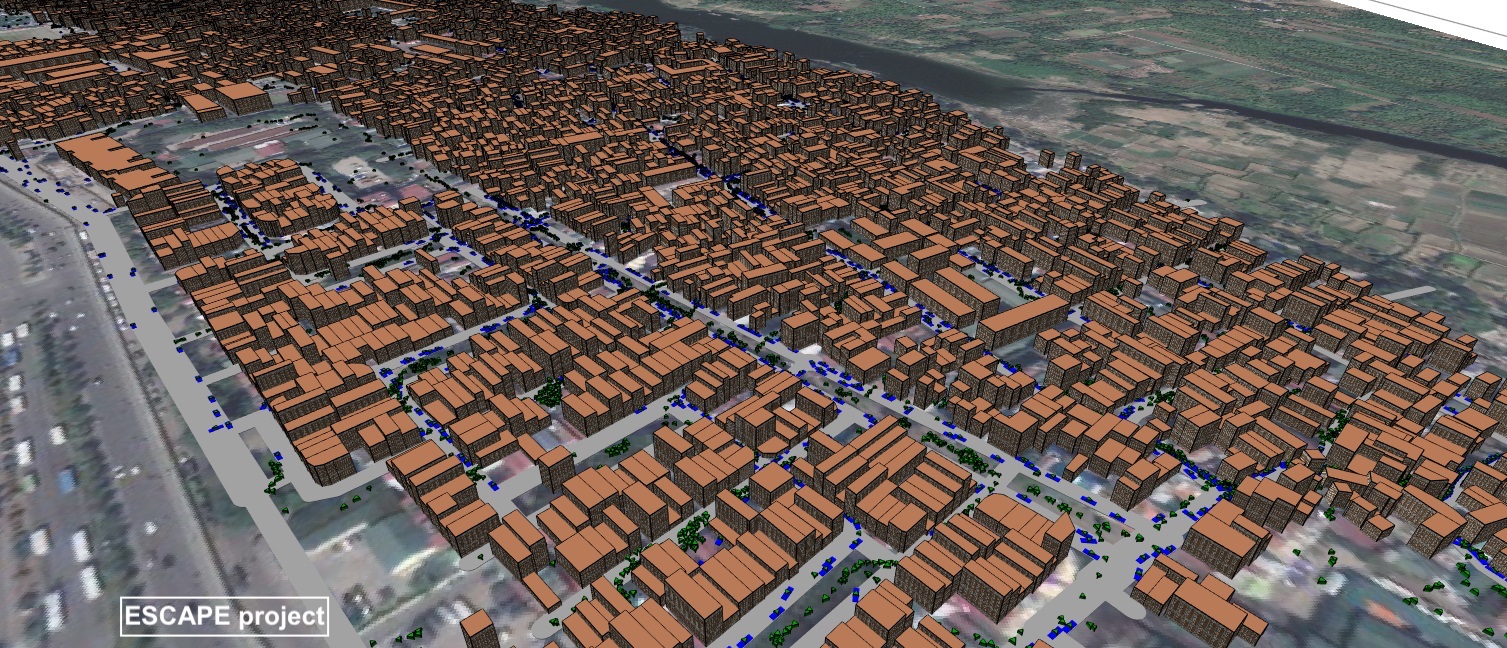
ESCAPE: Exploring by Simulation Cities Awareness on Population Evacuation (ANR 2016-2020)
Description:
A summary is available on the ANR website.
Publication:
Contact: Eric Daudé
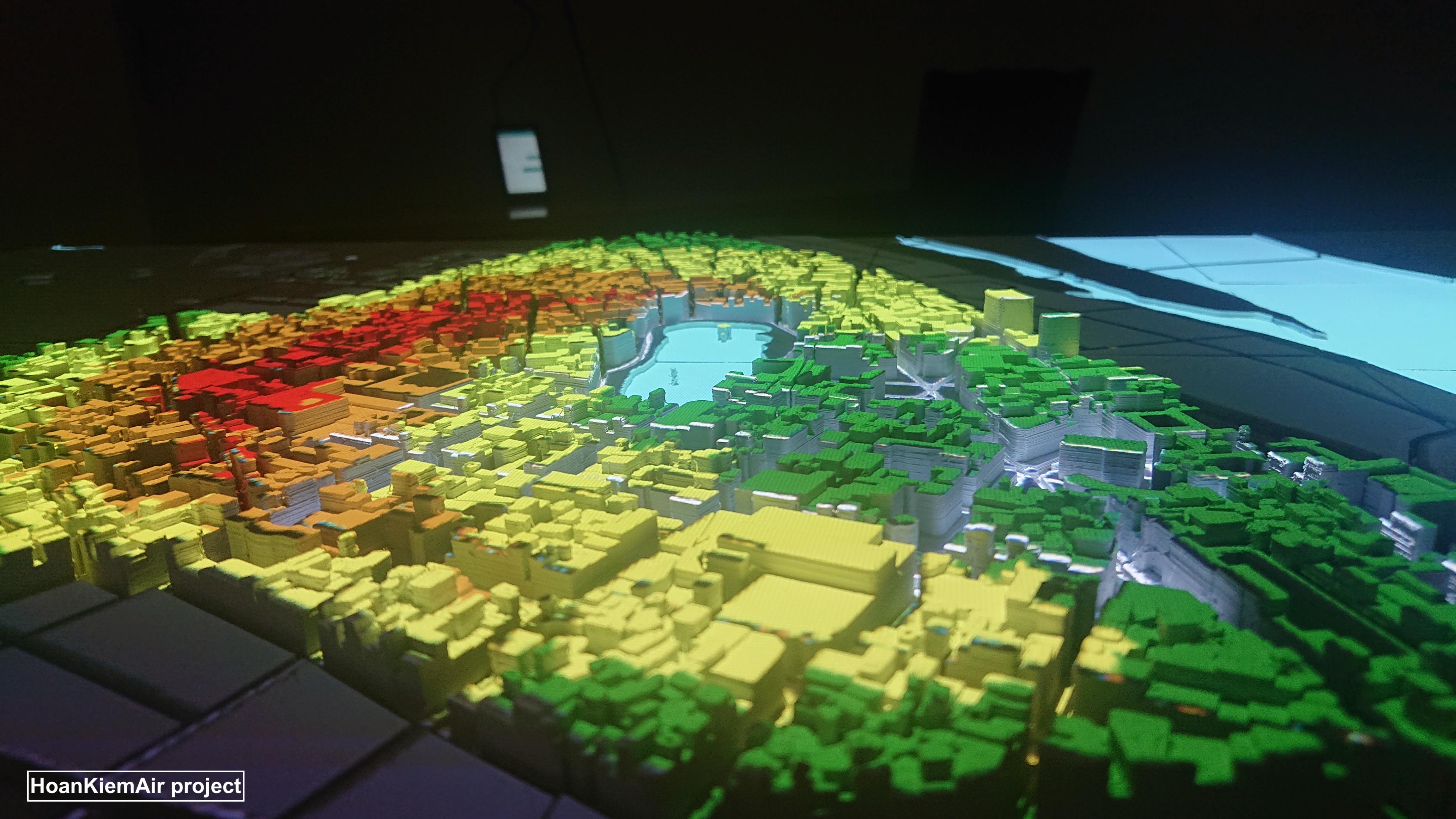
HoanKiemAir (French Embassy 2019-2020)
Description:
The development of permanent or temporary pedestrian areas, whether for leisure or to decrease air pollution, has become an integral part of urban planning in numerous cities around the world. Hanoi, the capital of Vietnam, began to implement its first area, around the iconic Hoan Kiem lake, a few years ago. In most cases, however, a road closure is likely to deport traffic to nearby neighborhoods with the consequences of intensifying congestion and, possibly, increasing air pollution in these areas. Because this outcome might appear counter-intuitive to most stakeholders, it is becoming more and more necessary to analyze, assess, and share the impacts of these developments in terms of traffic and pollution shifts before implementing them. In the HoanKiemAir project, we used the GAMA platform to build an agent-based model that simulates the traffic, its emissions of air pollutants, and the diffusion of these pollutants in the district of Hoan Kiem. This simulation has been designed so as to serve either as a decision support tool for local authorities or as an awareness-raising tool for the general public: thanks to its display on a physical 3D model of the district, people can effectively and very naturally interact with it at public venues. Although still in progress, the simulation is already able to reflect traffic and air pollution peaks during rush hours, allowing residents and developers to understand the impact of pedestrianization on air quality in different scenarios.
Publication:
Contact: Benoit Gaudou
ACTEUR: Cognitive Territorial Agents for the Study of Urban Dynamics and Risks (ANR 2014-2018)
Description:
Every year, the number of urban residents is growing. Diverse questions related to sustainability are rise from this growth. For example, for large and attractive territories, which urban planning policies to implement? How to manage and prevent technological or environmental hazards? Decision-makers have to take all of these issues into account when defining their urban planning policies. Unfortunately, the assessment of the impacts of possible policies is difficult due to the complex and stochastic interplay between society and infrastructure. One of the most promising approaches to face this difficulty is agent-based modeling. This approach consists in modeling the studied system as a collection of interacting decision-making entities called agents. An agent-based model can provide relevant information about the dynamics of the real-world urban system it represents. Moreover, it can allow them to be used as a virtual laboratory to test new urban planning policies. The use of agent-based models to study urban systems is booming for the last ten years. Another tendency is the development of more and more realist models. However, if models have to make a lot of progress concerning the integration of geographical and statistical data, the agents used to represent the different actors influencing the dynamic of the system (inhabitants, decision-makers...) are often simplistic (reactive agents). Yet, for some urban models, being able to integrate these cognitive agents, i.e. agents able to make complex reasoning such as planning to achieve their goals, is mandatory to improve the realism of models and test new scenarios. Unfortunately, developing large-scale models that integrate cognitive agents requires high-level programming skills. Indeed, if there are nowadays several software platforms that propose to help modelers to define their agent-based models through a dedicated modeling language (Netlogo, GAMA...) or through a graphical interface (Starlogo TNG, Modelling4All, Repast Symphony, MAGéo...), none of them are adapted to the development of such models by modelers with low-level programming skills: either they are too complex to use (Repast, GAMA) or too limited (Netlogo, Starlogo TNG, Modelling4All, Repast Symphony, MAGéo). As a result, geographers and urban planners that have no programming skills have to rely on computer scientists to develop models, which slows the development and the use of complex and realist spatial agent-based models. The objective of the ACTEUR project is to develop to help modelers, in particular geographers and urban planners, to design and calibrate through a graphical language cognitive agents able to act in a complex spatial environment. The platform has also for ambition to be used as a support of model discussion -participatory modeling- between the different actors concerned by a model (geographers, sociologists, urban planners, decision-makers, representatives...). These tools will be integrated into the GAMA platform that enables us to build large-scale models with thousands of hundreds of agents and that was already used to develop models with cognitive agents. In order to illustrate the utility and the importance of the developed tools, we will use them in two case studies. The first concerns the urban evolution of La Réunion island. The second case study will focus on the adaption to industrial hazards in Rouen. These two case studies are part of funded projects carried out by partners of the ACTEUR project.
Website:
Contact: Patrick Taillandier
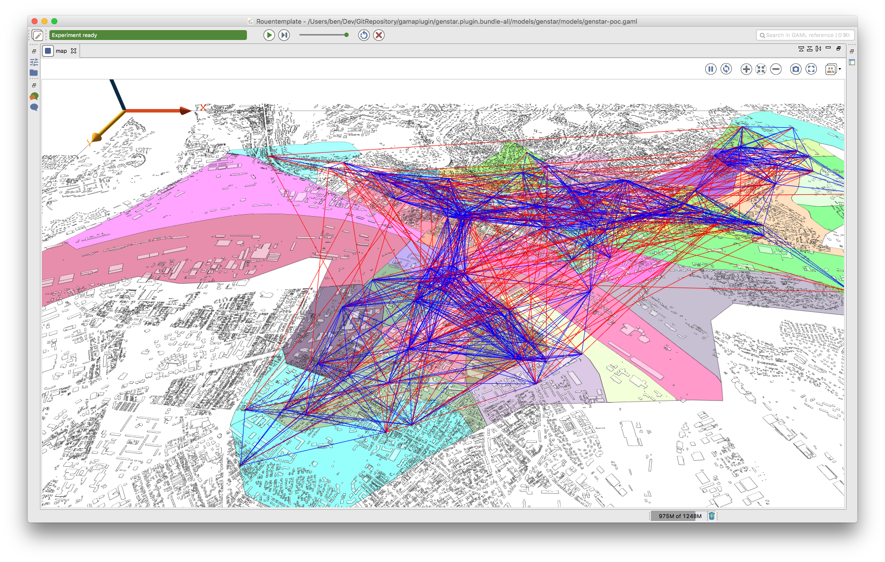
Genstar (ANR 2014-2016)
Description:
The Gen* project has the ambition to propose tools and methods to generate realistic synthetic populations for agent-based social simulation: it aims at combining applied mathematics and computer science approaches in order to incorporate arbitrary data and to generate statistically valid populations of artificial agents.
Publication:
Website: http://www.irit.fr/genstar/
Contact: Alexis Drogoul & Kevin Chapuis
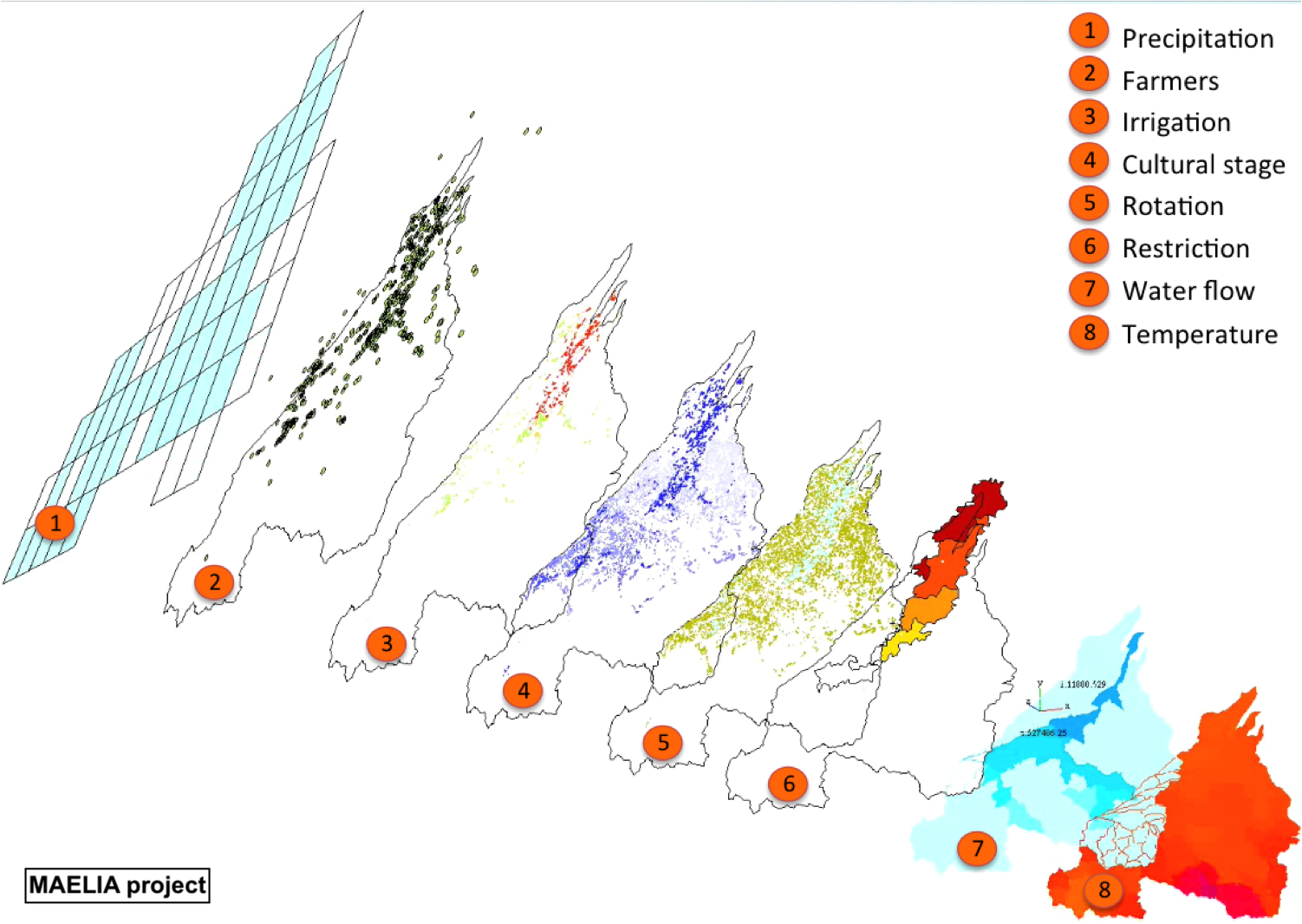
MAELIA
Description:
Maelia is a multi-agent platform for integrated assessment and modeling of agricultural territories (landscape) and territorial bioeconomy systems. It enables to assess the environmental, economic and social impacts of the combined changes in agricultural activities, transformation and recycling of biomass, natural resource management strategies (e.g. water) and global (demography, dynamics of land cover and climate changes).
Currently, this platform allows to handle at fine spatio-temporal scales the interactions between agricultural activities (rotation and crop management strategies within each production system), the hydrology of the different water resources (based on the SWAT® model's formalisms) and the water resources management (water withdrawals, restrictions, choices between resources). It is currently used to assess the impacts of scenarios (i) of distribution of agro-ecological cropping systems on green and blue water, nitrogen and carbon flows in watersheds, and (ii) of production exchanges between arable and livestock farmers on individual and collective environmental and socio-economic performances.
Publication:
Website: http://maelia-platform.inra.fr/
Contact: Olivier Thérond